
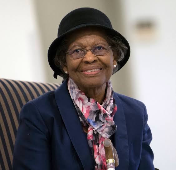
Gladys Mae West (27 October 1930 – 17 January 2026) was an American mathematician at the U.S. Naval Proving Ground in Dahlgren, Virginia. Her satellite geodesy work, which modelled the shape of the Earth, helped make GPS accurate. She was inducted into the Air Force Space and Missile Pioneers Hall of Fame in 2018.
Every time a phone finds your location, a ship plots a course or a pilot lines up an approach, it relies on GPS. Behind that technology is a long line of scientists and engineers. One of them, Gladys West, who spent decades doing precise mathematical work that almost nobody noticed until she was in her late eighties. Her career answers three questions:
What is the true shape of the Earth?
How do you measure it accurately enough for a satellite to find a position within metres?
And, who gets remembered for work like this?

Born: 27 October 1930, Sutherland, Virginia, USA
Died: 17 January 2026, Virginia
Career: Mathematician at the Naval base in Dahlgren, Virginia
Known for: Satellite geodesy and the mathematical modelling of the Earth
Who was Gladys West?
Gladys Mae West (née Brown) was an American mathematician whose satellite geodesy models were later incorporated into the Global Positioning System. She grew up in the Jim Crow era on a small farm in Dinwiddie County, south of Richmond. Her parents owned a small farm in an area populated mostly by sharecroppers. As a girl she worked on the family farm and passed time counting fenceposts, dreaming of a life beyond it.


From hand calculations to supercomputers at Dahlgren
In 1956 West was hired as a mathematician by the U.S. Naval Proving Ground in Dahlgren, Virginia, a weapons laboratory. She was only the fourth Black employee there. She met fellow mathematician Ira West on the base, and they married in 1957 and had three children.
At Dahlgren she was admired for solving complex equations by hand. In the early 1960s she took part in an astronomical study that showed the regularity of Pluto’s motion relative to Neptune. Over the following years the work moved from hand calculation to programming some of the most powerful computers of the day.
What did Gladys West do for GPS?

She calculated formulas involving gravity, radar and the planet’s dimensions. The Earth is not a perfect sphere. It bulges at the equator, and its surface and gravity vary from place to place. A navigation satellite can only report an accurate position if it works from a very precise model of that shape. Measuring and modelling the Earth this way is called satellite geodesy.
West processed satellite radar altimetry data, including data from the Seasat satellite. Her 1981 technical report on the Seasat data processing system is part of the public record. Her Seasat work led to GEOSAT, a satellite built to create computer models of Earth’s surface. Geosat went into orbit on 12 March 1984. Her work cut her team’s processing time in half, and she was recommended for a commendation in 1979.
The U.S. Space Force has said that without the mathematical model West and her team helped develop, GPS could not achieve its accuracy.
A PhD at 70
West worked at Dahlgren for 42 years and retired in 1998. She kept learning. In 2000, at the age of 70, she earned a PhD from Virginia Tech in public administration and policy affairs. She also wrote a memoir, It Began with a Dream, and spoke to schoolchildren about studying science, technology, engineering and maths.
Honours and recognition

2018 — Virginia Senate resolution
On 26 February 2018 the Virginia Senate passed a joint resolution commending her trailblazing career in mathematics and her vital contributions to modern technology.
2018 — Air Force Space and Missile Pioneers Hall of Fame
She was inducted on 6 December 2018 for her work on a highly accurate model of the Earth.
2018 — BBC 100 Women
She was named one of the BBC’s 100 Women of 2018.
2021 — Prince Philip Medal
The UK’s Royal Academy of Engineering awarded her the Prince Philip Medal, its highest individual honour.
Other recognition
She also received the Webby Lifetime Achievement Award and the IEEE President’s Award.
Frequently asked questions
Who was Gladys West?
She was an American mathematician who spent 42 years at the Naval base in Dahlgren, Virginia. Her satellite geodesy models were later incorporated into GPS.
Did Gladys West invent GPS?
No. Many scientists and engineers developed GPS over decades. West contributed an essential piece: an accurate mathematical model of the Earth’s shape. The U.S. Space Force has said GPS could not reach its accuracy without the model she and her team helped develop.
What is satellite geodesy?
It is the science of measuring the Earth’s shape, gravity field and orientation using satellite data. Navigation satellites need a precise Earth model to report an accurate position.
What did West work on at Dahlgren?
She calculated formulas involving gravity, radar and the planet’s dimensions. Her satellite altimetry work on Seasat led to GEOSAT.
When was Gladys West recognised for her work?
Mostly in 2018, when she was inducted into the Air Force Space and Missile Pioneers Hall of Fame, named to the BBC’s 100 Women list and commended by the Virginia Senate.
What awards did Gladys West win?
They include the Air Force Space and Missile Pioneers Hall of Fame induction (2018), BBC 100 Women (2018), the Royal Academy of Engineering’s Prince Philip Medal (2021), the Webby Lifetime Achievement Award and the IEEE President’s Award.
Found this article interesting? Subscribe to The Innovators Jam for articles, news, views, and write-ups on innovation, science and research.
Follow us on Instagram @theinnovatorsjam, Youtube @InnovatorsJam, LinkedIn @ The Innovators Jam







We would love to hear from you. Leave your reply here.